Positional Quality
In the paragraphs above the general principles behind how a GPS
receiver calculates a position was explained in simplified terms.
In the paragraphs below, some of the wide variety factors which
affect the quality of the GPS calculations will be discussed.
Positional Error and Ambiguities
This method of determining the location is based on a series
of calculations and averages determined from moving satellites
and a point, though stationary, with respect to the surface of
the Earth, is actually moving through space. Smalls errors can
be amplified by the long distance between the point and the satellites.
In order to reduce the effect of these errors, GPS receivers will
use information from all of the available satellites when making
positional calculations.
Satellite Geometry
The quality of a GPS position is affected by the arrangement
of the satellites, in addition to the number of satellites used.
The overall relative quality of satellite geometry at any point
in time can be determined based on the current geometric dissolution
of precision (GDOP). GDOP is a numeric representation of the potential
precision of a GPS position based on the geometry of the currently
visible satellite constellation. For the most part, the best results,
lower GDOP, are obtained when the satellites are spread out in
the sky. The exception to this is when the satellites begin to
approach the horizon.
The radio signals broadcast by the satellites have to travel
through Earth’s atmosphere, which can delay the signal and
introduce other errors. When a satellite is directly overhead,
the signal is passing through the least amount of atmosphere,
introducing the least amount of delay and other errors. As the
satellites move lower in the sky towards the horizon, the angle
between the point and satellites causes the signal to travel through
more and more of the Earth’s atmosphere, which causes a
greater amount of delay and a higher amount of errors. Many GPS
receivers, especially those used for higher precision operations
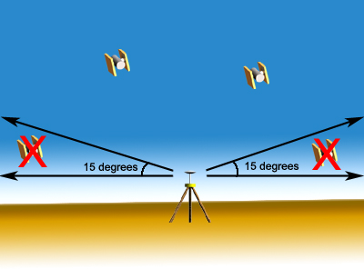
mask out the satellites that are too low in the sky, and will
only use data from satellites that are more than 10 or 15 degrees
above the horizon.
Codes and Carriers
Most of the commercially available handheld GPS receivers only
use the data received from the C/A code on the L1 frequency to
calculate their positions. Using the C/A code exclusively makes
the technology more affordable, but limits the accuracy of the
position to between 10 and 20 meters. More precise GPS receivers
use the P codes broadcast on the L1 and L2 frequencies, as well
as the carrier frequencies themselves. Keeping track of the carrier
frequencies phase and wavelength allows the receiver to more accurately
calculate the distance to the satellite.
Differential GPS
Up to this point, all of the GPS calculations discussed have
been concerned with locating a single point in space, but one
of the best ways to increase the accuracy of the GPS calculations
is to perform GPS observations on two points at the same time,
a technique known as differential GPS.
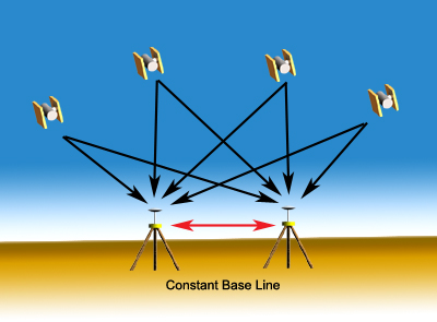
When using differential GPS (DGPS), one receiver is used as a
reference station. This receiver is set up over a point with known
coordinates. Another receiver is used to determine the location
of the unknown point. While the GPS data is being collected at
the two points simultaneously, the distance between the two receivers
remains constant. Introducing the constant baseline between the
two receivers into the GPS calculation increases the positional
accuracy significantly. When using the C/A code only, DGPS can
achieve accuracy in the range of 30 centimeters. With more sophisticated
receivers that use code and carrier to calculate positions can
achieve accuracies approaching 5 millimeters.
Top of Page
Global Positioning Systems : Next >>
GPS Surveying